Looking for design inspiration? Browse our curated collections!


The watermark at the lower right corner of the image will not appear on the final product.

by Paul Fearn
$28.00
Design Location
Color
Image Size
Product Details
Our Bella / Canvas t-shirts are made from a 50% cotton / 50% polyester blend and are available in five different sizes. All t-shirts are machine washable.
Design Details
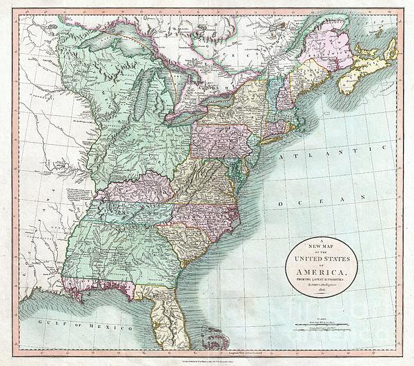
: Published by John Cary in 1806, this is one of the most interesting atlas maps of the United States to appear in the early 19th century. Covers the... more
Ships Within
1 - 2 business days
Average Rating (4.34 Stars):


Sherrie Yarbro
April 26th, 2024

We loved the T- shirt but needed the print for a cover for my husbands prosthetic leg. He was in an awful accident a year and lost a leg as a result. He is a Beatle Fanatic and we had to put them on his new leg. Thanks for the awesome art and it was the perfect size.
Suzanne Hale
April 19th, 2024

Very original shirt, lots of compliments- great fit.
Dana Frederickson
April 19th, 2024

This is an excellent t-shirt! An excellent view of an SAS Connect Airbus A320-251N coming in for a landing! I especially wanted to buy this t-shirt because I am of Swedish descent! Excellent photography and artwork!
Dana Frederickson
April 19th, 2024

This is an excellent t-shirt! An excellent view of a P I A Boeing 777 coming in for a landing! The t-shirt came out great! Excellent photography and artwork!
Dean Will
April 18th, 2024

Very pleased with the item!! But wrong color.
Simon Brown
April 13th, 2024

Great but Jaws fans saying it's spelt Pippit
: Published by John Cary in 1806, this is one of the most interesting atlas maps of the United States to appear in the early 19th century. Covers the entire United States east of the Mississippi River as well as parts of the Louisiana Territory and Canada. Much of the northwestern part of the United States is enclosed in the gigantic “Western Territory” encompassing all of modern day Ohio, Indiana, Michigan, Wisconsin, Illinois and parts of Minnesota. This area was largely the preserve of American Indian tribes and the occasional fur tapper. Notes many of the American Indian Nations occupying the territory north of the treaty line as defined by General Wayne in 1795. Further south, Georgia is shown extending westward as far as the Mississippi River despite the creation of the Mississippi Territory in 1798. Florida is divided at the Apalachicola River into eastern and western sections. West Florida, ostensibly part of the Louisiana Purchase, was claimed by the Spanish and remained u...
My passion is Photography and Aviation or is that Aviation and Photography ! I hope you enjoy my photographs.

Our return policy is very simple:
If you're not happy with a purchase that you made on FineArtAmerica.com, for any reason, you can return it to us within 30 days of the order date. As soon as it arrives, we'll issue a full refund for the entire purchase price. Please note - Fine Art America does not reimburse the outgoing or return shipping charges unless the return is due to a defect in quality.
Fine Art America sells thousands of pieces of artwork each month - all with a 100% money-back guarantee. We take great pride in the fact that hundreds of thousands of artists have chosen Fine Art America to fulfill their orders, and we look forward to helping you select your next piece!
All t-shirts ship from our production facility within 1 - 2 business days of your order.
$28.00


There are no comments for 1806 Cary Map of the United States east of the Mississippi River. Click here to post the first comment.