Looking for design inspiration? Browse our curated collections!


The watermark at the lower right corner of the image will not appear on the final product.

by Paul Fearn
$28.00
Design Location
Color
Image Size
Product Details
Our Bella / Canvas t-shirts are made from a 50% cotton / 50% polyester blend and are available in five different sizes. All t-shirts are machine washable.
Design Details
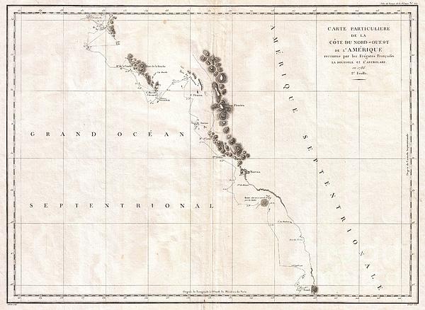
This is a fine example of La Perouse’s important 1787 mapping of Vancouver Island and the coastlines of Washington and British Columbia. When drawn... more
Ships Within
1 - 2 business days
Average Rating (4.34 Stars):


Sherrie Yarbro
April 26th, 2024

We loved the T- shirt but needed the print for a cover for my husbands prosthetic leg. He was in an awful accident a year and lost a leg as a result. He is a Beatle Fanatic and we had to put them on his new leg. Thanks for the awesome art and it was the perfect size.
Suzanne Hale
April 19th, 2024

Very original shirt, lots of compliments- great fit.
Dana Frederickson
April 19th, 2024

This is an excellent t-shirt! An excellent view of an SAS Connect Airbus A320-251N coming in for a landing! I especially wanted to buy this t-shirt because I am of Swedish descent! Excellent photography and artwork!
Dana Frederickson
April 19th, 2024

This is an excellent t-shirt! An excellent view of a P I A Boeing 777 coming in for a landing! The t-shirt came out great! Excellent photography and artwork!
Dean Will
April 18th, 2024

Very pleased with the item!! But wrong color.
Simon Brown
April 13th, 2024

Great but Jaws fans saying it's spelt Pippit
This is a fine example of La Perouse’s important 1787 mapping of Vancouver Island and the coastlines of Washington and British Columbia. When drawn in 1787 La Perouse’s map was the only available map of this region not based on the survey work of Captain Cook. The map covers the coastline from Cape Rond (Tillamook Head, Oregon) northwards past Vancouver Island as far the northwestern top of the Baie de Clonard (The Queen Charlotte Islands or Haida Gwaii). The cartography here may be a little hard to understand for most casual observers due Perouse’s use of archaic French language place names and well as a number of major errors. Perouse, like Cook, entirely missed the entrance to the Strait of Juan de Fuca, consequently Vancouver Island is erroneously attached to the mainland. Nonetheless, many of the sites visited by early explorers, including the Nootka Sound, the Bay of St. Louis (Quatsino Sound), Pointe Boisee (Cape Cook), Mont Fleurieu (Silverthrone Mountain), Cape Fleurieu...
My passion is Photography and Aviation or is that Aviation and Photography ! I hope you enjoy my photographs.

Our return policy is very simple:
If you're not happy with a purchase that you made on FineArtAmerica.com, for any reason, you can return it to us within 30 days of the order date. As soon as it arrives, we'll issue a full refund for the entire purchase price. Please note - Fine Art America does not reimburse the outgoing or return shipping charges unless the return is due to a defect in quality.
Fine Art America sells thousands of pieces of artwork each month - all with a 100% money-back guarantee. We take great pride in the fact that hundreds of thousands of artists have chosen Fine Art America to fulfill their orders, and we look forward to helping you select your next piece!
All t-shirts ship from our production facility within 1 - 2 business days of your order.
$28.00


There are no comments for 1786 La Perouse Map of Vancouver and British Columbia Canada. Click here to post the first comment.